NASA WorldWind 1.4 NASA WorldWind 1.4
Software Specifications
Version:
1.4 |
Size:
16.00 MB |
License [?]:
Freeware |
Price:
Not available |
Last Updated:
Jul 31, 2009 |
Category:
Science and Engineering Software |
Developer:
NASA Ames Research Center |
Operating System:
Windows 2000 Windows XP |
Additional Requirements:
Intel Pentium 3, 1 GHz, or AMD Athlon or higher, 256MB RAM, 3D Graphics Card, DSL/Cable Connection, 2GB disk space |
Limitations
Not available |
|
NASA WorldWind Review
" A graphically rich 3D virtual globe for use on desktop computers running Windows. Experience Earth terrain, just as if you were really there. "
|
|
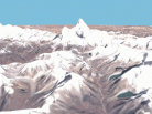
World Wind lets you zoom from satellite altitude into any place on Earth. Leveraging Landsat satellite imagery and Shuttle Radar Topography Mission data, World Wind lets you experience Earth terrain in visually rich 3D, just as if you were really there.
Virtually visit any place in the world. Look across the Andes, into the Grand Canyon, over the Alps, or along the African Sahara.
Features:
* 3D Engine
World Wind allows any user to zoom from satellite altitude into any place on Earth, leveraging high resolution LandSat imagery and SRTM elevation data to experience Earth in visually rich 3D, just as if they were really there.
* Blue Marble
World Wind has a full copy of the Blue Marble, a spectacular true-color image of the entire Earth as seen on NASA's Earth Observatory: the Blue Marble.
* Landsat 7
Using World Wind, you can continue to zoom past Blue Marble and reveal the extremely detailed seamless mosaic of LandSat 7 data. LandSat 7 is a collection of images from 1999-2003 at an impressive 15 m per pixel resolution.
* SRTM
Combining LandSat 7 imagery with Shuttle Radar Topography Mission (SRTM) Data, World Wind can display a dramatic view of the Earth at eye level. Users will literally be able to fly across the world in any direction.
* MODIS
Moderate Resolution Imaging Spectroradiometer or MODIS produces a set of time relevant data that's updated every day. MODIS catalogs fires, floods, dust, smoke, storms and even volcanic activity. MODIS images can download publication quality material at a resolution of 250 m per pixel. Anew fresh set of images can be downloaded every day.
* GLOBE
World Wind is capable of browsing through and displaying GLOBE data based on any time the user wants. For example, a user can download today's (or any previous day's) temperature across the world.
* Landmark Set
World Wind has the capability to display actual 3d models of landmarks on the earth.
* Visual Tools
World Wind comes with a variety of visual guides that help the user's experience such as latitude and longitude lines, as well as extremely precise coordinate data.
* Place names
World Wind has a full catalog of countries, capitals, counties, cities, towns, and even historical references.
* Country & (USA) State Borders
World Wind has a complete set of borders that traces every country and state. As you zoom into the world, the boundaries become more precise.
* NASA SVS
Goddard Space Flight Center (GSFC) has produced a set of visually intense animations that demonstrate a variety of subjects such as hurricane dynamics and seasonal changes across the globe.
|
Top Related Downloads
| 1. |
|
NASA WorldWind
A graphically rich 3D virtual globe for use on desktop computers running Windows. Experience Earth terrain, just as if you were really there. |
| 2. |
 |
Science Fair
Ten real-world applications of physics and math, ages 9-16. |
| 3. |
 |
3D Grapher
Plot and animate 2D and 3D equation and table-based graphs with ease. |
| 4. |
|
ES-Calc
A powerful Calculator and Units Conversion Tool for engineers and scientists. |
| 5. |
|
3DMath Explorer
A 3D graph plotting software for math, science and engineering. |
|
|